Thermal Data at Building Scale: The Commercial Constellations Come Online
EarthDaily aims to deliver commercial data from September, and SatVu is expanding its thermal fleet with fresh capital. What the new generation of private sensors can do for heat planning and site analysis, and where the limits are.
Eight satellites, 22 spectral bands
On 9 July 2026, the Canadian company EarthDaily Analytics placed its eighth satellite, EDC-08, into orbit on SpaceX's Transporter-17 rideshare mission. According to the company, that is the number it needs to begin commercial operations; the full constellation is to comprise ten satellites. Each satellite carries 16 imagers collecting data across 22 spectral bands, including channels in the short-wave and thermal infrared. The goal is a daily, radiometrically calibrated acquisition of the Earth's entire land surface, so that observations are comparable between regions and between overpasses.
In the spring, CEO Don Osborne said the company was on track to enter commercial operations, with data availability, beginning in September. The first images from satellites EDC-02 to EDC-07, released in July, confirmed the function of the optical channels; validation of the short-wave and thermal infrared channels was still under way at that point. At the time of writing, the company had not published a fixed start date for commercial service; its wording is "later this year".
Thermal as a business of its own
While EarthDaily offers thermal channels as part of a broad spectrum, the London-based company SatVu specialises exclusively in thermal infrared. Its first satellite, HotSat-1, delivered thermal imagery at a resolution of up to 3.5 metres, fine enough to distinguish individual buildings, roofs and industrial plants. In February 2026, SatVu closed a £30 million funding round with participation from the NATO Innovation Fund and the British Business Bank, among others, lifting its total equity funding to £60 million. Two further satellites, HotSat-2 and HotSat-3, were at that point slated for launch in 2026.
Other providers are building thermal constellations as well, such as the German company constellr and Spain's Aistech. The pattern is similar everywhere: small satellites, resolutions in the range of a few metres to a few dozen metres, and a business model based on repeated acquisitions of the same places.
What a thermal image at building scale shows
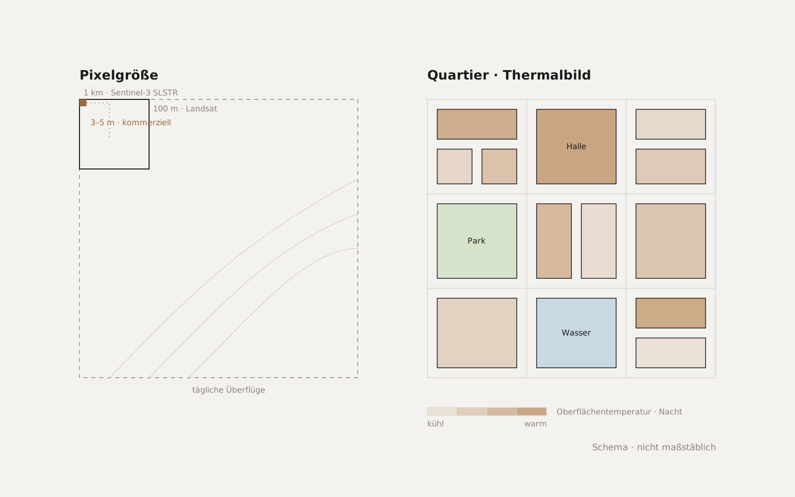
Public missions such as Copernicus Sentinel-3 or Landsat deliver surface temperatures at kilometre or 100-metre scale. That is enough to compare urban regions and document heat waves. For the questions raised by the Heat Planning Act, by heat-action plans or by site analysis for data centres, it is too coarse: which buildings in a neighbourhood lose the most heat in winter? Which halls in a business park are still radiating at night? Which streets fail to cool below 25 degrees on a hot night?
At resolutions of a few metres, these questions become answerable. A thermal image then shows not a neighbourhood but individual roofs, facades, car parks, rail yards and water bodies with their respective surface temperatures. From several acquisitions under different weather conditions, the thermal behaviour of a building stock can be described without entering a single building.
The limits remain
Three limitations are worth knowing. First, a satellite measures the temperature of the surface, not of the air and not of the interior; the link to heat losses or to perceived stress has to be established through models. Second, thermal remote sensing needs a cloud-free sky, and the number of usable acquisitions per year is limited in central Europe. Third, the young constellations are still being built up: EarthDaily is still validating its thermal channels, and SatVu does not yet have its full fleet in orbit. Anyone planning today is planning with a data situation that will improve considerably over the next twelve months.
In practice
For municipalities and site planners, this means the question is no longer whether thermal data at building scale will be available, but how to integrate it into existing procedures. A heat plan that designates suitable areas for heat networks, a heat-action plan that names cool places, or a site analysis for a data centre with waste-heat use can all draw on the same data basis. It makes sense to define now the indicators to be tracked year by year, so that the first acquisitions from the new constellations feed directly into the next update.
Sources
- EarthDaily: EarthDaily Constellation Entering Commercial Operations with Successful Launch III (9 Jul 2026)
- GlobeNewswire: EarthDaily Constellation Entering Commercial Operations with Successful Launch III
- Military & Aerospace Electronics: EarthDaily expands Earth observation constellation with eighth satellite
- SpaceQ: EarthDaily CEO discusses the launch of commercial operations and daily data capabilities
- SpaceNews: EarthDaily in Orbit – From First Launch to Commercial Operations
- EarthDaily: Early Images from Orbit – A Visual Showcase from EDC-01
- European Spaceflight: Earth Observation Data Provider SatVu Closes £30 Million Funding Round
- Via Satellite: SatVu Closes Funding Round of $40M, With NATO Innovation Fund Backing (17 Feb 2026)
- Payload: SatVu raises £30M to accelerate its constellation
- Sentinel Hub: Sentinel-3 SLSTR L1B